
There are several considerations when planning the EBC trek and things that’ll help you prepare well and pack accordingly. These include routes to know for your itinerary, amenities at tea houses in lower vs higher altitudes, weather conditions, access to food and water, important considerations for minimizing altitude sickness.
- Itinerary planning
- Why do I need the 2 buffer days?
- Weather patterns
- Facilities and tea houses as you ascend to higher altitudes
- Drinking water and hot drinks
- Things you can do to better take care of yourself in the mountains
Itinerary planning
Considerations for itinerary include:
- How many days do you have?
- Are you doing the classic route to Everest base camp or an extended route that includes Gokyo lakes area?
- Are you adding additional excursions to your hike days?
- Type of accommodation and facilities available in villages.
- Additional buffer days for weather and regional flight delays are required.
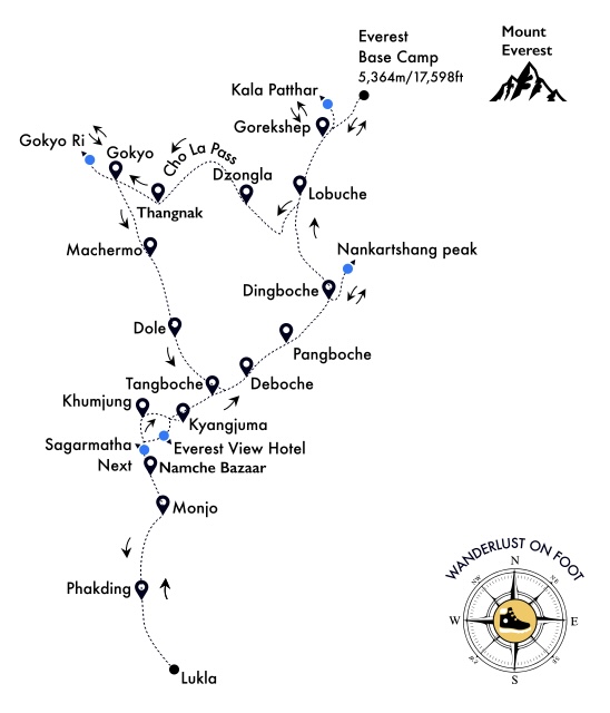
There are many routes in the Everest region that include additional trails across mountain passes. But if your main goal is to cover Everest Base Camp (EBC), I would recommend the following 2 options:
- Option 1 is the classic route to EBC.
- Option 2 involves continuing your journey through Cho La pass after EBC to get to Gokyo lake region.
There are other routes to consider doing a second time. One through Kongma La pass (the hardest pass in the region) and Renjo La pass (to Gokyo) or a separate route to Gokyo that branches off west from Tengboche. But if it’s your first time, I recommend focusing on the following 2 options and having EBC as your first destination goal before doing any of the mountain passes.
Option 1: Classic route to EBC (14 days – 12 trekking days + 2 buffer days)
Fly to Lukla and start hiking the same day with your first stop for the night at Phakding. After Phakding, you can customize your stops based on accommodation needs and mileage to be covered in a day. I’ve explained in a section below how you might customize your itinerary and excursion stops based on various factors. In Option 1, after you complete EBC, you hike back and return to Lukla.

| Day | Route | Elevation at destination | Distance |
|---|---|---|---|
| 1 | Fly: Kathmandu -> Lukla | 9,383ft/ 2,860m | – |
| 1 | Lukla -> Phakding | 8,563ft/ 2,610m | 5.0miles/ 8km |
| 2 | Phakding -> Monjo | 9,300ft/ 2,835m | 3.0miles/ 4.8km |
| 3 | Monjo -> Namche Bazaar | 11,286ft/ 3,440m | 3.4miles/ 5.4km |
| 4 | Namche Bazaar -> Khumjung | 12,434ft/ 3,790m | 2.4miles/ 3.8km |
| 4 (alt) | Namche Bazaar -> Kyangjuma | 11,811ft/ 3,600m | 3.0miles/ 4.8km |
| 5 | Khumjung -> Deboche | 12,200ft/ 3,718m | 4.6miles/ 7.4km |
| 5 (alt) | Khumjung -> Pangboche | 13,074ft/ 3,985m | 7.0miles/ 11.2km |
| 6 | Deboche -> Dingboche | 14,470ft/ 4,410m | 4.6miles/ 7.4km |
| 7 | Dingboche -> Nangkartshang peak -> return to Dingboche (Acclimatization) | 16,676 ft/ 5,083m | 3.1miles/ 5.0km |
| 8 | Dingboche -> Lobuche | 16,207ft/ 4,940m | 5.6miles/ 9.1km |
| 9 | Lobuche -> Gorakshep | 16,942ft/ 5,164m | 2.8miles/ 4.5km |
| 9 | Gorakshep -> Kalapatthar -> return to Gorakshep (Acclimatization) | 18,519ft/ 5,644m | 2.3miles/ 3.8km |
| 10 | Gorakshep -> Everest Base camp | 17,598ft/ 5,364m | 3.6miles/ 5.7km |
| 10 | Return: EBC -> Gorakshep -> Dingboche | 14,470ft/ 4,410m | 12.0miles/ 19.3km |
| 11 | Return: Dingboche -> Namche Bazaar | 11,286ft/ 3,440m | 13.7miles/ 22km |
| 12 | Return: Namche Bazaar -> Lukla -> Fly back to Kathmandu | 9,383ft/ 2,860m | 11.0miles/ 17.8km |
Customizing parts of the journey to suit your needs
Most itineraries to the base camp get you from Phakding straight to Namche Bazaar where you cover a lot of mileage and elevation gain in a single day – about 6.6 miles and a cumulative elevation gain of 5,400ft. If you decide to do this on a single day, then it’s better to stay in Namche Bazaar for two nights to acclimatize and also to help recover from the long hike. Another option is to break journey in Monjo and stay in Namche Bazaar for just one night. There are several excursions from Namche Bazaar which will make it a long day when you leave to get to your next village. On the day I left Namche Bazaar, we visited the Tenzing Norgay and Sherpa Heritage Museum, then went up to Sagarmatha Next and finally to Khumjung village where we visited the Khumjung monastery, the Hillary Secondary School and the Edmund Hillary Visitors center all in one day. There is also an option to go to Everest View Hotel which has spectacular views of the snow-capped mountains in the Himalayan range. By the time we completed our visit to Sagarmatha Next, it got cloudy and the visibility wasn’t that great. The trail from Sagarmatha Next splits into two, creating a little loop between Namche Bazaar, Khumjung and Kyamjuma. The east side trail goes through Everest view hotel while the one to the west, goes straight to Khumjung village. If you find yourself in a similar situation on a cloudy day with low visibility, you can skip the Everest view hotel altogether and take the shorter trail straight to Khumjung village. Khumjung village is the oldest established Sherpa village and is well worth the visit. Some people stay here while others just visit and move further east to stay in Kyangjuma as it’s a little further along the journey.
Khumjung village gives you a different kind of experience and vibe compared to Namche Bazaar. So if you decide to stay in Namche Bazaar only for one night, you will have an opportunity to stay again upon returning back from EBC. Read more about my experience in these two villages:
Namche Bazaar – the vibrant Sherpa town
Khumjung – Sherpa heritage and first view of Ama Dablam
As you move further along Khumjung, some itineraries have Pangboche as the next destination while others have Deboche. From my prior experience and observation, I found Deboche to have better hotels and facilities, more in line with a resort-like experience. I stayed at Rivendell lodge that had nice rooms with electric heated blankets and an attached bath. The dining room was spacious, cozy and welcoming with a large Tibetan mural. The facilities and type of accommodations may also be a factor for you to choose which village you plan to stay. The mileage you cover in a day may vary but there are trade-offs you’ll need to make along the way. For example, the mileage from Khumjung to Deboche is roughly 4.6 miles while Pangboche gets you further along by additional 2.4 miles because you’ll cover 7 miles in that day. In my opinion, it’s not much considering you’re still at a reasonable altitude of 12,000-13,000~ft and so it doesn’t feel too different. As you go further up in elevation beyond 14,000ft, that’s when it really begins to affect you but the higher you go, you have fewer choices too.
Should I hike Kala Patthar for sunrise or sunset?
There are definite trade-offs here in this decision making. Some people hike to EBC after lunch on the same day they arrive at Gorakshep and then hike Kala Patthar the next early morning for sunrise. This calls for waking up at 2:00am and starting the hike in bitter cold without a proper breakfast. I strongly advise against it mainly because of my personal experience dealing with high altitude conditions without a good breakfast. It really messes you up!
Read my blog about my miserable experience without having a decent breakfast before the hike to Gorakshep.
Onward to Everest Base Camp – The Big day
If I were to do this again, I would hike EBC on day 10 instead of day 9 (like how I have suggested here) and hike Kala Patthar on day 9 for sunset. The trade-off here is that views may not be that great because of the mountain weather patterns bringing clouds and less visibility in the afternoon. If you’re lucky, the clouds may clear momentarily. In any case, doing this hike up Kala Patthar even half way or going up a 1000+ ft is a good idea for acclimatization. Your hike to EBC the next day will be much more manageable than what I experienced. Some people say you don’t sleep very well at that altitude so there’s no point. But that wasn’t the case for me. I was so tired after the hike to EBC on the same day I got to Gorakshep and I remember having a decent night’s sleep. It helped me a lot toward my onward journey across Cho La pass for the next 2 days.
Can I do this in 12 days instead of 14?
On Day 10, you could take a helicopter from Gorakshep back to Kathmandu via Lukla. This will certainly shave off the 2 days of return hike. So you’ll need 10 days + 2 buffer days to account for flight delays. Read my blog about helicopters, regional flights and their reliability:
Helicopter ride to Lukla – Rooftops, Terraced fields and snow-capped mountains in the horizon
Option 2: EBC and Gokyo via Cho La pass (17 days – 15 trekking days + 2 buffer days)
The route from Lukla to EBC is the same as Option 1 above until Day 9. You could do this route counter-clockwise too by getting to Gokyo before going east. But I recommend checking off EBC first if that’s your primary goal. By the time I finished my hike to EBC, I was well acclimatized and so my hike up Cho La pass was much more enjoyable without any symptoms of altitude sickness. I had no headaches or nausea and I was able to fully enjoy the immersive experience that Cho La pass offered me. Read my blog about my experience through Cho La pass:
Trekking through Cho La pass – a stunning glacier hike
| Day | Route | Elevation at destination | Distance |
|---|---|---|---|
| 10 | Gorakshep -> Everest Base camp | 17,598ft/ 5,364m | 3.6miles/ 5.7km |
| 10 | EBC -> Return: Gorakshep -> Dzongla | 15,912ft/ 4,830m | 10.2miles/ 16.4km |
| 11 | Dzongla -> Thangnak via Cho La Pass Highest point is 17, 782ft/ 5,420m | 15,400ft/ 4,693m | 5.4miles/ 8.6km |
| 12 | Thangnak -> Gokyo | 15,584ft/ 4,754m | 2.0miles/ 3.2km |
| 13 | Gokyo valley -> Gokyo Ri -> Gokyo valley | 17,575ft/ 5,357m | 2.2miles/ 3.6km |
| 13 | Gokyo -> Dole | 13,248ft/ 4,038m | 7.7miles/ 12.5km |
| 14 | Return: Dole -> Namche Bazaar | 11,286ft/ 3,440m | 10.0miles/ 16.0km |
| 15 | Return: Namche Bazaar -> Lukla -> Fly back to Kathmandu | 9,383ft/ 2,860m | 11.0miles/ 17.8km |
Should I hike Gokyo Ri for sunrise or sunset?
You’ll get the best views of the Himalayan range from Gokyo Ri. If you missed views from Kala Patthar because of a cloudy afternoon, this view is even better and you’ll be able to see Cho Oyu from here and all of the mountains on the east including Mount Everest. I highly recommend a morning hike when the skies are clearer. But since the hike from Thangnak to Gokyo is short one, your window of opportunity is much wider for an evening sunset hike on the same day, provided the weather is good. If you do successfully complete Gokyo Ri on Day 12, you can use Day 13 for a relaxing hike around the lakes or save a day and start hiking back.
If you choose to do a sunrise hike, it doesn’t need to be too early where you wake up in the middle of the night, 4:00am should be sufficient. This is much more relaxing and the views are incredible no matter what time of dawn you get there. I unfortunately missed this hike because I ended up falling sick on the last day and this makes me even more determined to go back and hike the three passes to experience this missed opportunity.
Can I do this in 15 days instead of 17?
On Day 13, you could take a helicopter from Gokyo back to Kathmandu via Lukla. This will certainly shave off the 2 days of return hike. So you’ll need 13 days + 2 buffer days to account for flight delays.
Why do I need the 2 buffer days?
The weather in the Himalayas is unreliable and you will need to account for flight delays. If you’re planning your return in the evening or late afternoon, there is a very high chance the flight will be cancelled that day because of weather patterns bringing in clouds by afternoon. Your best window of opportunity to fly is in the mornings.
Weather patterns
One consistent and notable trend of the Himalayan range is that clouds start gathering by noon and weather changes rapidly after that. You could get a bit of snow flurries for a couple of hours or end up with a cloudy and windy afternoon. If the clouds are stubborn, the trend continues and you might experience overnight snow. Your best bet is to start your hike as early as possible to make the most of the weather for the day. Have an early dinner and sleep early. Almost all tea houses accommodate breakfast as early as 5:30am so you can get a good head start for the day.
Facilities and tea houses as you ascend to higher altitudes
After Dingboche, the tea houses start getting more rustic and very basic. Lobuche and Gorakshep are really basic with no running water or flush toilets. It gets very cold at freezing temperatures and you rely a lot on layers, woolen base layers and a down jacket. Zero degree sleeping bags are a must. Forget hot showers or any showers at all. You’re better off without it as you’ll lose body heat very quickly when you take layers off and it takes a big toll on your immune system working hard to stay warm. Not worth the money you’ll pay either for a hot shower (1000 Nepali rupee per shower!). WiFi and charging stations cost about the same. So, choose wisely when you really need WiFi and bring your own battery pack. Read my post about Country side hotel in Dingboche and the hot shower facility there.
Day 6: Deboche to Dingboche – A cold afternoon snow shower with the yaks
Clean water is unreliable at the higher altitudes. It takes a long time for water to reach boiling point and if tea houses are crowded, there is a risk of food being cooked in water that doesn’t fully reach boiling point. To stay safe and healthy, I advise people to get their own jet boil from any of the stores in Lukla that sell camping and hiking gear. Get your own backpacking dry meals for 2-3 days starting from Lobuche to Gorakshep and back to Lobuche. Hot water is expensive in the tea houses. Each cup costs 150 Nepali Rupees. You’ll get your bang for your buck with the Jet boil!
Drinking water and hot drinks
There’s bottled water everywhere. As much as I hate using plastic bottles, I felt safer to use bottled water at higher altitudes where the water source was questionable. In all other places, it makes sense to just get water from the kitchen in a platypus or hydration pack and add aqua tabs for the night. Nevertheless, there is quick access to bottled water everywhere in case you run out. As I mentioned earlier, do not rely on hot water for drinking at higher altitudes as the water may not reach boiling point and it may still have contaminants, not to mention, the costs are as high as 500 Nepali rupees per flask which is about a liter or so. So use your own jet boil if you want hot water for tea. Don’t forget to bring your own camping mess kit. The crowds there had every other person coughing and sniffling. With so many people to cater to, I doubt whether the utensils get washed properly and there’s also the question of the water source for cleaning.
Drinking hot drinks will help boost your immune system, so make sure you carry instant tea or ginger powder for higher altitudes to mix and make your hot drink. I recommend the ginger powder mix from Trader Joe’s or an Ayurvedic tea (e.g. Samahan brand)
Things you can do to better take care of yourself in the mountains
- Always leave the day with a high protein breakfast (eggs) and slow carbs (porridge). This is important when you get to higher elevations.
- Drink plenty of fluids and hot drinks to boost your immune system. Eat foods with lots of garlic and ginger that will help you prevent altitude sickness. Teahouses have foods like garlic soup and sherpa stew that are really good for you.
- When you’re at altitudes above 14,000ft, start warm and wear additional layers when you begin the day’s hike. In the North east US, where I do winter hiking in much lower altitudes, I tend to start cold as I get warm very quickly. That is not the case here. The air is so thin that the temperature feels much colder and your body takes more than an hour to warm up even after you walk for a while. A couple of mornings I had to start my hike with my puffy on top of 4 other layers! Your body’s immune system gets severely compromised with the cold and its prudent to stay warm.
- Avoid showers for the same reason. You will lose body heat very quickly and your body will have to work hard to generate heat.
- Stick to a routine, a familiar pattern and don’t change things around too much. This includes food habits, packing/ repacking routines paying attention to where you packed your essentials. This will ensure you don’t stress out and look for things, spending extra energy than you need to.
- You’ll need to pick and choose your trade-offs. Should you do the sunrise hike to Kala Patthar (that requires you to wake up at 2:00am and hike in the bitter cold) or rather conserve your energy for EBC when you’re well rested and well fed before the hike. If you absolutely want to do the sunrise hike, eat something before you leave and carry nutrition bars. If you’re continuing your journey to Cho La pass, it may not be worth doing the sunrise hike. Gokyo Ri is a better option with more window of opportunity for clearer skies.
- Finally, go slow. Hike with smaller steps and walk slowly making sure to not let your heart rate spike up too quickly. This is key to preventing altitude sickness at higher elevations. There’s a term for it in Nepal – “Vistare-Vistare” or “Slowly-Slowly”….such is life in the Himalayas.
